Alghero |
l'AlguerAnnotations on the history of the territory
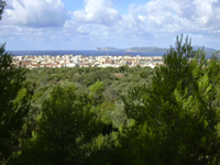
Traditional rural architecture in the countryside of Alghero has been highly conditioned by the history of the city. Town walls closed off the old centre in Catalan (l'Alguer vella) for centuries from the rest of the territory, which remained unpopulated from the middle ages until the eighteen hundreds.
In all truth, this has not always been the case. During the Nuragic civilization, the Alghero territory had a constant if not diffuse population, with a hundred or so nuragici Sardinians recorded on census. Later a gradual process of progressive concentration of the population, stemming from Roman times, benefited the region that, over hundreds of years, had seen a notable reduction in the number of populated centres.
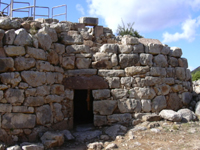
During the middle ages at the time of the Catalan-Aragonese conquest, the countryside around the fortified village was witness to typically small sporadic settlements where not only some of the oldest and clearest remains of Nuragic civilization can be found but also the ruins of somewhat abandoned villages.
In the 14 th century, the towns of de Suyana, Erquilo, and Essella, situated far away in la Nurra, in the confines of the Sàsser territory, were already destroyed, when Pere III conceded them to Alghero. The towns of Llunafras (capital), Tis, S. Marc, and Vessus that came under the protection of the Nulauro, much closer to Alghero, are already abandoned.
During the first Catalan-Aragonese period, there is a further reduction in the inhabited and therefore cultivated territories. This is due to the oppressive strategy put into action after the conquest, which, forced out the autochthonous population and confiscated their property. New legislation meant that the newcomers were obliged to reside on the inside of the fortified town and they were forbidden from sleeping in the countryside for safety reasons.
This situation intensely marked the structure and physical aspect of Alghero by posing a limit to the maximum number of houses, and deeply affected the identity and culture of the inhabitants, sadly enclosed in their hideaway. It is a significant fact that even today in Alghero instead of talking about going to the countryside they talk about going to the outside. The town of Alghero, enclosed within its walls, like many other medieval fortresses, at least until the 16 th century, still tended to have many non built-up areas. These were often marginal pieces of land at the edges of the fortifications, or small empty spaces between the buildings. According to ancient documents, there is evidence of different spaces such as patios, courtyards, vegetable plots, flower gardens, and grasslands.
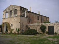
These open space satisfied many different functional requirements related to agricultural activities within the city walls. There is also a marked presence on the inside of the town walls of stalls, places to conserve products for the countryside, mills, canteens and other places inserted between living quarters or in more rustic building separated from the rest. Rural elements within the fortified walls conserved for centuries and many functional structures linked to the countryside activity have survived up to present day.
The people who worked the land in Alghero up until the seventeenth century were obliged to return to the city to spend the night. Therefore, cultivated land was for centuries limited to the narrow strips close enough to the stronghold for the workers to be able to travel to, usually on foot, every day. This was probably no more than 10% of the territory. The rest of the area was surrounded by a huge expanse of uninhabited land, covered with natural vegetation, called salts.
The prohibition against living in the countryside and its effects not only on the structure of the spaces and on the culture explains the quite modest dimension of traditional rural town planning in Alghero, up until the nineteenth century.
From the sixteenth century onwards, the cultivated strips of land gradually become larger, but the habit of returning to the city at nightfall continued for several more centuries even when spending the night on the outside was no longer an offence. For many centuries, therefore agricultural activities such as the cultivation of wheat, tending to vineyards and intensive specialist cultivation of vegetable gardens and orchards was only possible in the land closest to the city, that which can be defined as the historic countryside. As from the eighteenth century, the rural town planners gradually introduced reforms and invested more resources, more consistently. Olive grows began to substitute large areas of vineyards. In the 19 th and 20 th centuries, the arrival of large capitalist estates take up large expanses of land, that had before been destined to grazing pasture rather than crops. Significant agrarian transformation begins during the fascist regime in the lands of la Nurra and ends soon after the world war. Eventually there is more land becomes cultivated, and new establishments arise thus giving a new lease of life to a very different landscape.
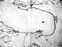
A map drawn up by Rocco Capellino el 1577 offers an image of Alghero as an unpopulated territory where human settlement is limited to the fortified town. The immediate surroundings marked with roadways that come together in the direction of the town centre is empty, excluding the chapels, free of buildings.Joan Oliva
Nurac de Palmavera
l'Alguer
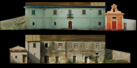
la Puríssima
l'Alguer
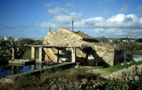
Caseta de l'hort a la Piverada
l'Alguer
Àngel Custodi
l'Alguer
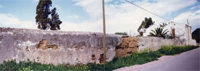
Paret de confí al camí d'Ungies
l'Alguer
Mapa de l'Alguer
Rocco Capellino (1577)